Showing posts with label indus. Show all posts
Friday, May 28, 2010
Leh.....Srinagar Via Khardung La......On The Roof Of The World......
Riding On The World's Most Scenic Road....
Barley field.....
The journey from Leh to Srinagar takes you from desert to lush valleys, from a Buddhist region to an Islamic one.
Lamayuru is set in the midst of some rather strange scenery. The road through the mountains dips into a gorge that in turn opens up into moonscape badlands, with rounded, yellow pinnacles and meditation caves carved into the mountainside. Lamayuru - the oldest monastery in Ladakh, dating from the 11th century – perches quietly near the top of the mountain, overlooking the badlands. Its whitewashed walls glowed in the evening sun, which cast eerie shadows across the landscape below as we settled into our hotel for the night.
Lamayuru monastery
Lamayuru Monastery buildings
At Fotu La, the highest point of the Leh to Srinagar road....
Early the next day, about half an hour from Lamayuru, we reached the Fotu La (‘la’ means ‘pass’). At 4,100m it was the highest point of our journey. Compared with the Khardung La near Leh, the world’s highest motorable pass at 5,602m, which comes complete with souvenir shops, cafes and thousands of prayer flags, the Fotu La is pleasantly modest. There is only this sign Craig is standing next to, a few prayer flags and a satellite dish. There weren’t any other cars around either.
Fotu La
30kms short of Kargil...
The road between Leh and Srinagar used to be narrow and treacherous. Part of the army’s job is to help maintain it, as well as protect the border against militant insurgents from both Pakistan and Kashmir. Lengthy convoys of around 20 army trucks frequently passed us, in both directions. They invariably kicked up plenty of dust but their presence was vaguely reassuring.
Cattle and ther road in Nubra valley
Large-Heading out towards Kargil
33 kilometres before Islamic Kargil, Mulbekh is the last outpost of Buddhism in Jammu & Kashmir. A large relief of Buddha is carved into this jut of rock and Buddhists travel many miles to pay their respects here, but there were plenty of men wearing Muslim-style lunghis and kurtas in the village as well.
Road To Kargiil...
Flowers Everywhere,The scenery also began to take on tinge of green as our journey took us to lower altitudes and rainier climes.
The road from Leh to Srinagar cuts right through Kargil, the most important site of the 1999 Kargil War, which kicked off when Pakistani soldiers and Kashmiri freedom fighters crossed the Line of Control.
. Continued....
Sunday, May 16, 2010
Tso Moriri - A Blue Pearl In Highland
Changthang is a vast high altitude plateau situated in the north-east of the region, bordering Tibet. The altitude varies between 14 to 15000 feet. It is the home of Changpa nomad tribes, a pastoral community who eke out living from their flock of pashmina goats and sheep. Temperature during winter falls below - 50 degrees C. It is a desolate wilderness, a haven of tranquility. No soul is seen for miles and miles. Occasionally tents of the nomads and their herd only are met with in these astounding landscapes.
In such absolute wilderness and an ocean of silence, at an altitude of 4572 m, 240 km from Leh lies a serene sapphire-blue lake, Tso Moriri, alive with variety of water birds during summer months. The region has many hot water springs and.abundance of wildlife enjoying their undisturbed habitat. There are three different routes to reach the plateau and Tso Moriri. Route that follows upstream of Indus River is the easiest, shortest and without any high altitude pass. We follow this route. It is a lonely and long way to the Lake.
On a beautiful tuesday morning,cool and pleasant with clear blue sky, we were all set for the night out and camping in the farthest land in Ladakh.On Leh-Manali highway, past Karoo we reached Upashi. Here we left the Manali highway and continue along picturesque Indus valley,past Himya and Kere we reached hot water spring at Chumathank on the bank of Indus.Steaming hot water oozes out at several places from the spring. From one of the locations it is piped to the bathrooms for bathing. The water of the spring has therapeutic value.
After a drive of 5 km we left Indus valley, crossed Indus River and turned east. We now followed a small singing brook passing through a narrow valley at times widening but mostly narrow with bare rocky hills staring from above.There was rich green vegetation on the valley floor and around villages. The rose-bush - the omnipresent flowering plant of Ladakh,was in bloom and showed its presence everywhere; in sheltered pockets and in bare rocks devoid of soil and the air was filled with their pleasant aroma.
The valley opened up at Kiari, became broad for some distance then closed into a narrow terrain. We reach a picturesque spot of Namshang on the edge of a stream carpeted with green grass on which stood a small parachute tent restaurant, providing snacks and hot cup of tea. This was a lone shop in a lonely place.Few pasmina sheep wee grazing nearby in a green patch.we were in Changthang Plateau, the high altitude bald pastures between 14 to 15000 feet elevation. This was an expansive empty space in the tranquil wilderness, where wild animals move about freely with the time and space entirely to themselves or to the animals of the nomadic herders.

We resumed our journey on the dirt road and after a short drive suddenly we saw a vast beautiful lake with clear blue waters surrounded by hills. The pretty lake dominated the landscape in which brahmini ducks and geese were wading in the shallow waters.
A small village Korzok with its hilltop monastery is the only habitation in the area. We walked along the periphery of the lake beyond Korzok Village to watch the amber-pink glow of the dying day. The sun was about to set. The long rays of setting sun turned the lake shimmer with golden hue. The low hills in the surround got lit up with faint glow. It was a beautiful end of the day. Soon after night felt and it was all quiet.
We settled for the tent colony called the Nomadic Life Camp (Tsomo riri), Korzok for our night sojourn. The double flapped, double bed tents with comfortable mattresses and comforters tents look brand new and were lined in two rows. It is a neat campus with hygienic toilets with flowing water taps and flushes. A water channel passes in between two rows of tents which makes the site more romantic. It is a nice tent colony with friendly and hospitable owner and workers. The food served was rich and tasty; organic as is claimed by the owner.
It was glorious to be out here far away from home at an altitude of 14500 ft on the bank of Tso Moriri to spend the night in the Korzok village of Changthang plateau.
It was a long and dreary night; extremely cold; temperature falling below zero degree.
It was an unforgettable experience. And I can not thank god enough for this great experience. I was amazed how the Changpa herdmen live in these high altitude cold and absolute wilderness and love it! I believe they have Angels for company and are in commune with God all the time. I feel that here the earth is very close to heaven and divide is so thin that you can feel His presence and hear Him talk to you.
Posted by amitap at 5:50 AM 0 comments
Labels: altitude, blue, changthang, high, indus, korzok, Ladakh, Saaphire, tso Moriri
Wednesday, May 12, 2010
Ladakh-Riding Through The land Of Mountains and Deserts
Land Of Lamas
One word makes every adventurer hold his breath in anticipation...one word makes every naturalist think of the ideal place to be...one word makes every traveler think of an exotic destination...one word makes a pilgrim think of salvation...Himalayas. Yes, the Himalayas with its rugged mountain peaks, evergreen forests, bone chilling regions, ancient temples, makes it an ideal destination for everyone: traveler, pilgrim or hardcore adventurer.

This was a testing time indeed. A stretch of 96 kms to Rumtse via, Tanglang La (17,852 ft asl) with nothing in-between except the rolling mountains.


After Rumtse we moved ahead to reach Leh while visiting the Buddhist Gompas at Hemis, Thikse and Spituk. Hemis Monastery is the oldest in the Ladakh region and is a seat of Buddhist culture and religion. We wondered at the beautiful murals and the enormous statues of Buddha/ Maitreya/ Chamba and Taradevi. Thikse Gonpa is the largest in the region and is built covering a huge hillock. Spituk monastery is situated very near Leh city and dates back to 14th Century AD.

This was a testing time indeed. A stretch of 96 kms to Rumtse via, Tanglang La (17,852 ft asl) with nothing in-between except the rolling mountains.


After Rumtse we moved ahead to reach Leh while visiting the Buddhist Gompas at Hemis, Thikse and Spituk. Hemis Monastery is the oldest in the Ladakh region and is a seat of Buddhist culture and religion. We wondered at the beautiful murals and the enormous statues of Buddha/ Maitreya/ Chamba and Taradevi. Thikse Gonpa is the largest in the region and is built covering a huge hillock. Spituk monastery is situated very near Leh city and dates back to 14th Century AD.

Ladakh is a unique region with diverse landscapes: brown sandy deserts and purple, rust cliffs amidst snow clad mountains, where summer is lush green and winter is snow white. And the people are always willing to help travellers, a smile seemingly permanently imprinted on their faces, despite the rigours of their lives.


Our onward journey was to the unexplored regions of Nubra Valley via Khardung La (18380 ft asl) the worlds highest motorable road. The road took us through the most exotic regions where we were beset with surprises throughout our odyssey. The first a stretch was of sand dunes in the middle of snow clad mountains. We had to rub our eyes and pinch ourselves to believe that there exists a desert amidst the snow peaks.


Monday, May 10, 2010
Ladakh....The Land Of Rocks,A Trekker's Paradise...
Ladakh--Trekker's Paradise
Ladakh - the land of many passes, of freezing high barren landscapes lying across the lofty Asian tableland - is among the highest of the world's inhabited plateaus. Remote yet never isolated, this trans Himalayan land is a repository of a myriad cultural and religious influences from mainland India, Tibet and Central Asia.

The first impression of Leh was that of a desert with green patches fed by the Indus. One of the first things you notice are the prayer wheels with ringing bells. As Leh is 3,505 m above sea level, most tourists experience a degree of altitude sickness. The symptoms are persistent headaches, dizziness, drowsiness, bleeding and blocked nose, and/or shortness of breath. It is because your body has not yet acclimatized to the comparative lack of oxygen. So the tourism department suggests you take complete rest for at least 48 hours.

Amidst starkly beautiful and majestic mountains, gradually merging into an oasis of green fields, Leh is situated, on the banks of the Indus, at a height of 11,000 feet. For seven months a year, Leh airport is Ladakh's only link with the outside world. Transport, tour operators, boarding and lodging facilities are available to suit every pocket and there is sufficient novelty, antiquity, hospitality and bargains to satisfy the quest of all types of visitors. With a population of 10,000 people, mainly Buddhist, some Argoos (Muslim descendants of Yarkandi traders) and a small Christian community, Leh bears the distinct stamp of its history as the administrative, commercial and cultural capital of Ladakh. A memorable sight of the Leh bazar is the group of women, traditionally attired, selling fruits, vegetables and household articles spinning and knitting, and exchanging gentle banter between themselves and with passersby.
Leh, the Ladakhi capital, sprawls from the foot of a ruined Tibetan-style palace - a maze of mud-brick and concrete. Leh only became the regional capital in the seventeenth century, when Sengge Namgyal shifted his court here from Shey, 15 km southeast, to be closer to the head of the Khardung La-Karakoram corridor into China. (Khardung La is the world's highest pass, 39 kms from Leh).
Predominantly Buddist, Leh has 25% Muslim population.These are Ladakhi Muslims, with their own cultural heritage, quite distinct from elsewhere.

The first impression of Leh was that of a desert with green patches fed by the Indus. One of the first things you notice are the prayer wheels with ringing bells. As Leh is 3,505 m above sea level, most tourists experience a degree of altitude sickness. The symptoms are persistent headaches, dizziness, drowsiness, bleeding and blocked nose, and/or shortness of breath. It is because your body has not yet acclimatized to the comparative lack of oxygen. So the tourism department suggests you take complete rest for at least 48 hours.

Amidst starkly beautiful and majestic mountains, gradually merging into an oasis of green fields, Leh is situated, on the banks of the Indus, at a height of 11,000 feet. For seven months a year, Leh airport is Ladakh's only link with the outside world. Transport, tour operators, boarding and lodging facilities are available to suit every pocket and there is sufficient novelty, antiquity, hospitality and bargains to satisfy the quest of all types of visitors. With a population of 10,000 people, mainly Buddhist, some Argoos (Muslim descendants of Yarkandi traders) and a small Christian community, Leh bears the distinct stamp of its history as the administrative, commercial and cultural capital of Ladakh. A memorable sight of the Leh bazar is the group of women, traditionally attired, selling fruits, vegetables and household articles spinning and knitting, and exchanging gentle banter between themselves and with passersby.

Leh, the Ladakhi capital, sprawls from the foot of a ruined Tibetan-style palace - a maze of mud-brick and concrete. Leh only became the regional capital in the seventeenth century, when Sengge Namgyal shifted his court here from Shey, 15 km southeast, to be closer to the head of the Khardung La-Karakoram corridor into China. (Khardung La is the world's highest pass, 39 kms from Leh).
Predominantly Buddist, Leh has 25% Muslim population.These are Ladakhi Muslims, with their own cultural heritage, quite distinct from elsewhere.

Ladakh is a trekkers' paradise. Foreigners move around with their backpacks, heading in different directions. Attractions in and around the town itself include the former palace and Namgyal Tsemo gompa. A short walk across the fields, the small monastery at Sankar harbours accomplished modern tantric murals and a thousand-headed Avalokitesvara deity.
Among the string of picturesque villages and gompas within reach by bus are Shey, site of a derelict seventeenth-century palace, the spectacular Tikse gompa and the Hemis gompa, the largest in the region. Tikse has a huge statue of the sitting Buddha.
The mosque, city palace, the bazar and the gompas are all within walking distance. Shey, Spituk and Phyang are quite close while Stok, Mashro, Thikse, Stakna, Chenlrey, Hemis, Likir, Basgo and Alchi are all a day's touring distance with regular bus and taxi services plying daily. Rumbak and Markha offer exciting treks, while Stok Kangri is the best for a climb. Boating and river running too is possible on the Indus.


Friday, May 7, 2010
Ladakh-Land Of Freezing Winds And High Passes...
The Breath Taking Manali--Leh High Way
A land of freezing winds and burning hot sunlight, Ladakh is a cold desert lying in the rain shadow of the Great Himalayas and other smaller ranges. Little rain and snow reaches this dry area, where natural forces have created a fantastic landscape. Surrounded by rugged mountains this land is completely different from the green landscape of many parts of the Himalayas. Bounded by two of the world's mightiest mountain ranges, the Great Himalaya and the Karokaram, it is a land which has no match.Ladakh is one of the most beautiful hill stations, with those beautiful landscapes, green valleys, gorgeous lakes and those soothing snowy peaks. In here you breathe in the mild air and breathe out all your stress and tension.
The breath-taking view at every turn of the Manali-Leh highway imprints images that remain long after. In summer, a stream of buses and Enfield motorcycles set off from the Kullu Valley to travel along the second highest motorable road in the world, which reaches a dizzying altitude of 5,328m. It's surface varies wildly, from bumpy asphalt to dirt tracks sliced by glacial streams. This 485 km journey along different river valleys takes around 24 hours with an overnight camp at Sarchu at an altitude of 4,000 m. This highway is open only for 3 months (between July 15th and Sep 15th approx.) every year. During the other seasons of the year it is closed because of the snow.One word makes every adventurer hold his breath in anticipation...one word makes every naturalist think of the ideal place to be...one word makes every traveler think of an exotic destination...one word makes a pilgrim think of salvation...Himalayas. Yes, the Himalayas with its rugged mountain peaks, evergreen forests, bone chilling regions, ancient temples, makes it an ideal destination for everyone: traveler, pilgrim or hardcore adventurer.
From Manali, the road crosses the Beas to begin its long ascent of the Rohtang Pass (3,900m). The views over the eternal snows of Solang Nala improve as you progress up, ranging from the coniferous forests to grassy mountain pastures. Just below the pass, the bus stops for a breakfast halt beside some dhabas. Nearby, a temple crowns the top of a bluff from where you get a great panoramic view of the upper Beas Valley. Rohtang La (La means "Pass" in Tibetan) is the gateway to the rugged regions of Lahaul and Spiti. The pass between two 5,000-meter peaks, is one of the most treacherous passes in the region. People have been stranded there sometimes due to the sudden deterioration of weather. Rohtang literally means "pile of dead bodies".
The descent from Rohtang to the floor of the Chandra Valley affords tantalizing glimpses of the shining white sail massif. Koksar is where the road finally reaches the river. I can't forget the parathas we had there. They were aaloo-stuffed parathas, deep fried, yet not oozing oil, served with a Tibetan chutney. Finger-licking irresistible! .

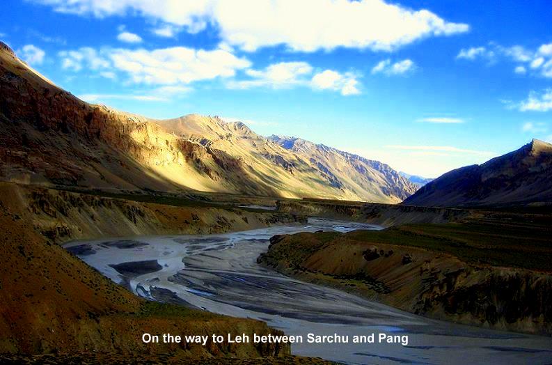
From Darcha, the road climbs steadily along the mountain side of wine-red and pale-green scree to Zingzing Bar. As you move from this desolate land, you approach Baralacha La, which will blow your mind. The "twelve-horned" pass forms the head of three valleys, the Bhaga, the Chandra, and the Yunan. By the time you get to Sarchu Serai you'll be ready for a night's rest, which is in a tent. This is in the plains next to Bagha river at the bottom of a high, straight peak. Some makeshift dhabas serve you dal-chawal for dinner.
You head to Lachlang La (5,059m) from Sarchu, the second highest pass on the highway,
before descending to Pang at 4,500m. 3 km from Pang is the extraordinary Moray Plains (4,800m), a 45-km-long plateau encircled by rolling hills and brilliant white Himalayan peaks. The road starts its ascent from Dibring Camp to Tanglang La at a head-spinning 5,328m. This is the second highest pass in the world and by the time you reach there, your nose might well start bleeding slightly. This is a symptom of altitude-sickness. (More about this later). The Karakoram range of the Himalayas, visible from here signals that you are approaching Ladakh. This road goes along our age-old Indus (Sindhu) valley. Sindhu is the river which was the lifeline of India for thousands of years. It fed one of the oldest civilizations of the world (Indus Valley civilization). It is natural to feel overwhelmed at the sight of this great river. 
The Gateway to Ladakh from Manali is Upshi. This is where the project for constructing and maintaining the highway, undertaken by the Indian army concludes. Considering the rugged terrain of the mighty Himalayas, maintaining this road itself is a Herculean task. Project Himank, as it is called, is amazing. One roadside board read, "If you want a road to the moon, please contact Himank". And we didn't find any exaggeration in it!

Posted by amitap at 4:21 AM 0 comments
Labels: baralacha la, beas, high way, himachal, Himalayas, indus, jispa, lachlang la, Ladakh, leh, manali, mountains, pangong, passdarcha, rohtang, sarchu, zanskar
Subscribe to:
Posts (Atom)


